

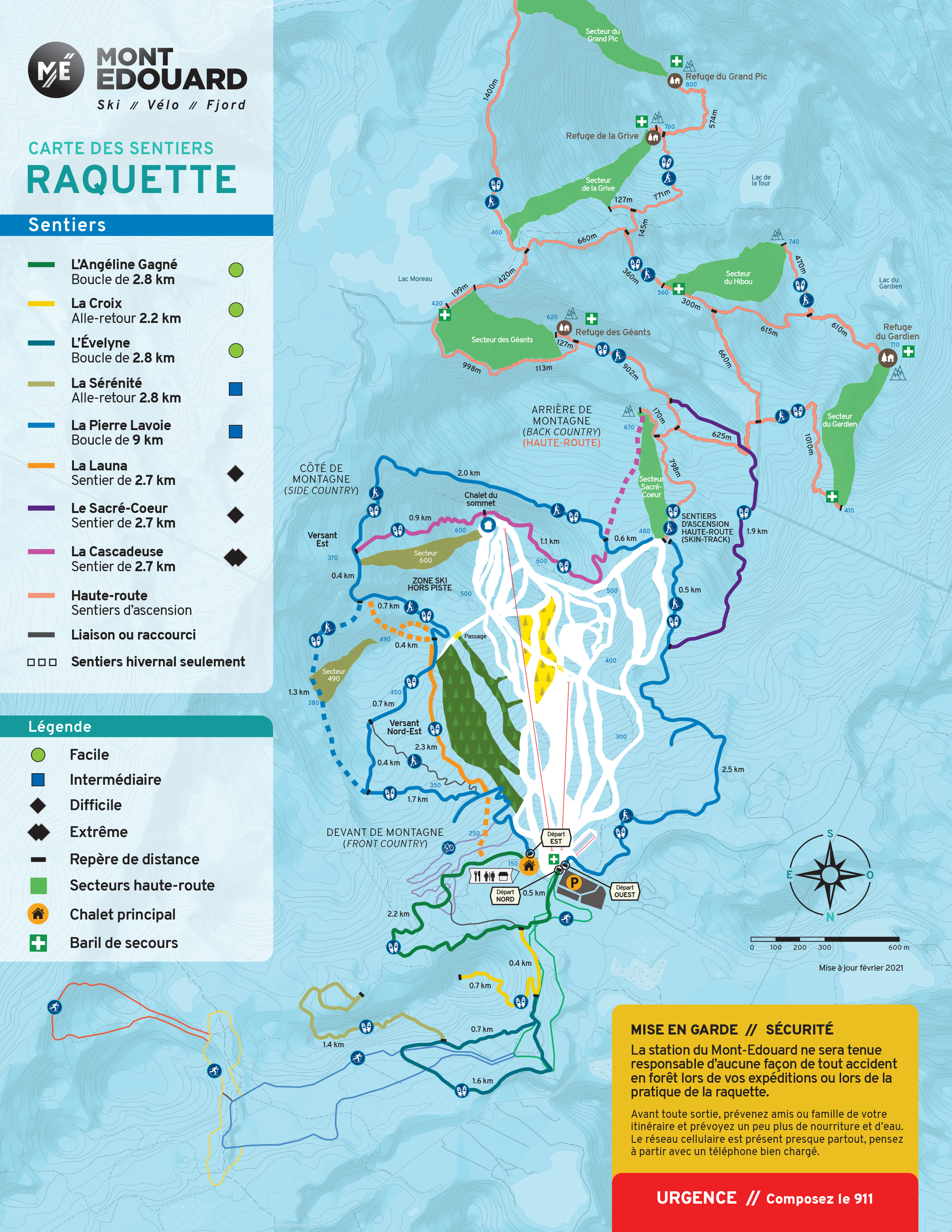
A 32 km network.
The network now includes 32 km of trails of various levels of difficulty that take you to many beautiful observation points. Look at the map to choose your route, it is available online or at the reception. Please note that some snowshoe trails are also used for ski touring. Please respect other users and give way to faster hikers. Thank you!
Opening hours: 9:00 to 3:30
Cost: 8,70$ + TAXES (Free for the Season pass holder)
Trails are off the beaten path, so please use caution. Please consider snow conditions, weather, and your ability when planning your hike. Bring water, a snack, a whistle and extra clothing for windy areas. Communicate your plans with someone in case you may need help. Cell phone service is available almost everywhere, so bring your phone with a full charge.
Trail description
Angeline Gagné - Green square - white border: easy 2.8 km; 150 m climb
Most of this trail is easy. A few valleys with short slopes require a little extra effort to get up and down.
La Croix - yellow square; blue border: Difficult / 1.1 km / Ascent 200 m.
This trail starts at the Angeline Gagné and climbs to a summit with interesting views. Most of this trail is not very difficult except for a short difficult section at the top due to a very steep slope. Note that the trail is a dead end so you have to retrace your steps. The round trip length of the station is 3.2 km.
Evelyne - Blue square/yellow border - Easy/2.8 km/40m climb
This trail is a nice loop in a forest and next to a stream. It leaves the La Croix Trail before the hill. The total round trip length of the station is 3 km.
Serenity - Yellow square/blue border - Difficult/1.3 km/climb 120m
This trail starts from the Evelyne and goes over a summit before descending to the foot of a rock face. It is a dead end with a small loop at the end. The total round trip length of the station with the Evelyne loop is 7.7 km.
Pierre Lavoie Trail - White Square/Blue Border - Intermediate/9 km/ 500 m climb
This trail goes around Mont Edouard via the pass between Mont Edouard and Mont Sacré-Cœur. It provides access to other trails and several observation points. The section behind Mont Edouard runs along the foot of a rock face. It is a beautiful route without major obstacles.
The main route passes through Cap des Bouleaux and the Vallée des Bouleaux. There are two short steep slopes to reach the crest. An alternative route follows the winter route through several small valleys.
The first 1.5 km section in each direction gives access to an observation point with a beautiful view.
Launa - yellow square, blue border - Difficult/2.7 km/210m
This trail passes on the northeast plateau in a straight line near Cap des Bouleaux. The slopes on both sides are steep. It is a fast track that allows hikers to make several interesting loops or to go straight down to the main lodge.
Cascadeuse - purple square; white border: Extreme/2.7 km/climb 475 m
This trail passes by two peaks: Sacré-Coeur and Mont-Édouard. There is a steep section near each summit. The section east of the summit of Mont Edouard is extreme due to steep slopes of 0.9 km; it is recommended for experienced hikers only. The loop from the station that includes Sacre-Coeur, Cascadeuse, Launa and Pierre Lavoie trail is 11 km with a total climb of 820 m.
Sacre-Coeur - blue square/white border or white arrow - Difficult/2.7 km/climb 350 m
This trail starts from the Pierre Lavoie trail and climbs the west ridge of Sacre-Coeur. It joins the haute-route trail on the west ridge. From there you have two choices: stay on the ridge for 0.8 km to reach the refuge des Géants or turn at 0.7 km to the main summit of Sacré-Coeur. Then comes the ascent to Mont Edouard via the Cascadeuse, the climb on the west side is difficult and sustained. The loop from the station with the Pierre Lavoie trail on the west side of Mont Edouard is 9.0 km with a total climb of 590 m.
Haute-route climbing Trail - red square; white border
These trails provide access to the summit of Sacré-Coeur, Mont Laure-Gaudreault (La Grive sector) and Le Gardien for backcountry skiers and snowshoers. There are four huts at the top of the different high road sectors. The total length (round trip) from the station to the Grive hut on Mont Laure-Gaudreault is 9.6 km with a total climb of 900 m.
